
Gracias por apoyar a este sitio ❤️
Haz una donación
Haz una donación
Mapa topográfico Misty Ridge
Haga clic en el mapa para ver la altitud.
Gracias por apoyar a este sitio ❤️
Haz una donación
Haz una donación
Acerca de este mapa
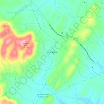
Nombre: Mapa topográfico Misty Ridge, altitud, relieve.
Altitud media: 274 m
Altitud mínima: 226 m
Altitud máxima: 387 m
Gracias por apoyar a este sitio ❤️
Haz una donación
Haz una donación
Otros mapas topográficos
Haga clic en un mapa para ver su topografía, su altitud y su relieve.
Hopewell
United States > Tennessee > Bradley County
According to the United States Census Bureau, the CDP has a total area of 7.1 square miles (18 km2), all land. It sits at an elevation of approximately 722 feet (220 m) above sea level, one of the lowest elevations in Bradley County.
Altitud media: 254 m
Gracias por apoyar a este sitio ❤️
Haz una donación
Haz una donación