
Mapa topográfico Dehradun
Mapa interactivo
Haga clic en el mapa para ver la altitud.
Acerca de este mapa
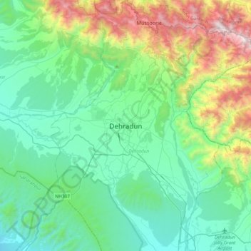
Nombre: Mapa topográfico Dehradun, altitud, relieve.
Lugar: Dehradun, Dehradun District, Uttarakhand, 248001, India (30.16556 77.88368 30.48556 78.20368)
Altitud media: 904 m
Altitud mínima: 402 m
Altitud máxima: 2.568 m
The city of Dehradun mainly lies in Doon Valley and is at a varying height from 410 m (1,350 ft) in Clement Town to above 700 m (2,300 ft) at Malsi which is 15 km (9.3 mi) from the city. However, the average elevation is 450 m (1,480 ft) above sea level. Malsi is the starting point of Lesser Himalayan Range that extends to Mussoorie and beyond. Jaunsar-Bawar hills in Dehradun district rises to 3,700 m (12,100 ft) above sea level. The hilly region of Mussoorie goes up to a height of 1,870–2,017 m (6,135–6,617 ft) above sea level. Its geomorphological and meteorological characteristics make it prone to a number of natural hazards. Beside earthquakes, the region is frequently devastated by landslides, cloudbursts, flash-floods, cold waves and hailstorms.
Otros mapas topográficos
Haga clic en un mapa para ver su topografía, su altitud y su relieve.
Mussoorie
India > Uttarakhand > Dehradun
Mussoorie, Dehradun, Uttarakhand, 248179, India
Altitud media: 1.594 m
dwara
India > Uttarakhand > Dehradun > Dehradun
dwara, Dehradun, Uttarakhand, 248001, India
Altitud media: 868 m
Chandrabani
India > Uttarakhand > Dehradun > Dehradun
Chandrabani, Dehradun, Uttarakhand, 248001, India
Altitud media: 607 m
Rispana River
India > Uttarakhand > Dehradun > Dehradun
Rispana River, Dehradun, Uttarakhand, 248001, India
Altitud media: 624 m
dhanaula
India > Uttarakhand > Dehradun > dhanaula
dhanaula, Dehradun, Uttarakhand, 248009, India
Altitud media: 1.011 m