
Gracias por apoyar a este sitio ❤️
Haz una donación
Haz una donación
Mapa topográfico Ormiston
Haga clic en el mapa para ver la altitud.
Gracias por apoyar a este sitio ❤️
Haz una donación
Haz una donación
Ormiston
Ormiston is a village in East Lothian, Scotland, near Tranent, Humbie, Pencaitland and Cranston, located on the north bank of the River Tyne at an elevation of about 276 feet (84 m).
Gracias por apoyar a este sitio ❤️
Haz una donación
Haz una donación
Acerca de este mapa
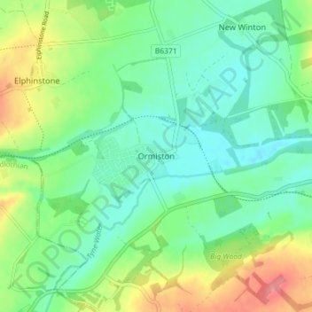
Nombre: Mapa topográfico Ormiston, altitud, relieve.
Lugar: Ormiston, East Lothian, Scotland, EH35 5HT, United Kingdom (55.89285 -2.95984 55.93285 -2.91984)
Altitud media: 102 m
Altitud mínima: 75 m
Altitud máxima: 159 m
Gracias por apoyar a este sitio ❤️
Haz una donación
Haz una donación
Otros mapas topográficos
Haga clic en un mapa para ver su topografía, su altitud y su relieve.