
Gracias por apoyar a este sitio ❤️
Haz una donación
Haz una donación
Mapa topográfico Underwood
Haga clic en el mapa para ver la altitud.
Gracias por apoyar a este sitio ❤️
Haz una donación
Haz una donación
Acerca de este mapa
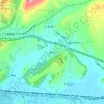
Nombre: Mapa topográfico Underwood, altitud, relieve.
Lugar: Underwood, Newport, Gwent, Wales, NP18 2HQ, United Kingdom (51.57676 -2.90946 51.61676 -2.86946)
Altitud media: 38 m
Altitud mínima: 2 m
Altitud máxima: 169 m
Gracias por apoyar a este sitio ❤️
Haz una donación
Haz una donación
Otros mapas topográficos
Haga clic en un mapa para ver su topografía, su altitud y su relieve.