
Mapa topográfico River Windrush
Mapa interactivo
Haga clic en el mapa para ver la altitud.
Acerca de este mapa
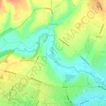
Nombre: Mapa topográfico River Windrush, altitud, relieve.
Altitud media: 101 m
Altitud mínima: 79 m
Altitud máxima: 125 m
Otros mapas topográficos
Haga clic en un mapa para ver su topografía, su altitud y su relieve.
Witney
United Kingdom > England > West Oxfordshire > Witney
Witney, West Oxfordshire, Oxfordshire, South East, England, OX28 6BJ, United Kingdom
Altitud media: 95 m
Carterton
United Kingdom > England > West Oxfordshire > Carterton
Carterton, West Oxfordshire, Oxfordshire, South East, England, OX18 3XX, United Kingdom
Altitud media: 95 m
Burford
United Kingdom > England > West Oxfordshire > Burford
Burford, Oxfordshire, South East, England, OX18, United Kingdom
Altitud media: 140 m
Tackley
United Kingdom > England > West Oxfordshire > Tackley
Tackley, West Oxfordshire, Oxfordshire, South East, England, OX5 3FR, United Kingdom
Altitud media: 94 m
River Evenlode
United Kingdom > England > West Oxfordshire
River Evenlode, West Oxfordshire, Oxfordshire, South East, England, OX29 8DW, United Kingdom
Altitud media: 106 m
Soho Farmhouse
United Kingdom > England > West Oxfordshire > Little Tew
Soho Farmhouse, Great Tew, Little Tew, West Oxfordshire, Oxfordshire, South East England, England, OX7 4JS, United Kingdom
Altitud media: 163 m
Asthall
United Kingdom > England > West Oxfordshire > Asthall
Asthall, West Oxfordshire, Oxfordshire, South East England, England, United Kingdom
Altitud media: 129 m
Upper Milton
United Kingdom > England > West Oxfordshire > Milton-under-Wychwood > Upper Milton
Upper Milton, Milton-under-Wychwood, West Oxfordshire, Oxfordshire, South East England, England, OX7 6EY, United Kingdom
Altitud media: 153 m
Mount Skippett
United Kingdom > England > West Oxfordshire > Ramsden > Mount Skippett
Mount Skippett, Ramsden, West Oxfordshire, Oxfordshire, South East England, England, OX7 3AP, United Kingdom
Altitud media: 135 m
Radford
United Kingdom > England > West Oxfordshire > Kiddington > Radford
Radford, Enstone, Kiddington, West Oxfordshire, Oxfordshire, South East England, England, OX7 4EB, United Kingdom
Altitud media: 141 m
Woodstock
United Kingdom > England > West Oxfordshire > Woodstock
Woodstock, West Oxfordshire, Oxfordshire, South East England, England, OX20 1TH, United Kingdom
Altitud media: 93 m
Bladon
United Kingdom > England > West Oxfordshire > Bladon
Bladon, West Oxfordshire, Oxfordshire, South East, England, OX20 1RQ, United Kingdom
Altitud media: 86 m
Nether Worton
United Kingdom > England > West Oxfordshire > Nether Worton
Nether Worton, Worton, West Oxfordshire, Oxfordshire, South East England, England, OX7 7AT, United Kingdom
Altitud media: 131 m
River Glyme
United Kingdom > England > West Oxfordshire
River Glyme, West Oxfordshire, Oxfordshire, South East, England, OX7 4EB, United Kingdom
Altitud media: 133 m
Kingham
United Kingdom > England > West Oxfordshire > Kingham
Kingham, West Oxfordshire, Oxfordshire, South East, England, OX7 6YE, United Kingdom
Altitud media: 125 m
Widford
United Kingdom > England > West Oxfordshire > Widford
Widford, West Oxfordshire, Oxfordshire, South East, England, OX18 4DU, United Kingdom
Altitud media: 127 m
Foscot
United Kingdom > England > West Oxfordshire > Foscot
Foscot, West Oxfordshire, Oxfordshire, South East, England, OX7 6RJ, United Kingdom
Altitud media: 121 m
Worton
United Kingdom > England > West Oxfordshire
Worton, West Oxfordshire, Oxfordshire, South East, England, United Kingdom
Altitud media: 128 m
Blenheim
United Kingdom > England > West Oxfordshire
Blenheim, West Oxfordshire, Oxfordshire, South East, England, United Kingdom
Altitud media: 99 m
Cornbury and Wychwood
United Kingdom > England > West Oxfordshire
Cornbury and Wychwood, West Oxfordshire, Oxfordshire, South East, England, United Kingdom
Altitud media: 146 m