
Mapa topográfico Magherafelt
Mapa interactivo
Haga clic en el mapa para ver la altitud.
Acerca de este mapa
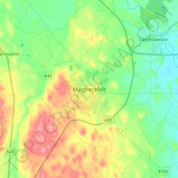
Nombre: Mapa topográfico Magherafelt, altitud, relieve.
Altitud media: 59 m
Altitud mínima: 14 m
Altitud máxima: 133 m
Otros mapas topográficos
Haga clic en un mapa para ver su topografía, su altitud y su relieve.
Maghera
Royaume-Uni > Irlande du Nord > County Londonderry
Maghera, County Londonderry, Ulster, Irlande du Nord, BT46 5AE, Royaume-Uni
Altitud media: 72 m
Mullaghmore
Royaume-Uni > Irlande du Nord > County Londonderry
Mullaghmore, County Londonderry, Ulster, Irlande du Nord, BT45 7DZ, Royaume-Uni
Altitud media: 390 m
Londonderry/Derry
Royaume-Uni > Irlande du Nord > County Londonderry
Londonderry/Derry, County Borough of Londonderry, County Londonderry, Irlande du Nord, BT48 6BU, Royaume-Uni
Altitud media: 88 m