
Mapa topográfico Jammu and Kashmir
Mapa interactivo
Haga clic en el mapa para ver la altitud.
Acerca de este mapa
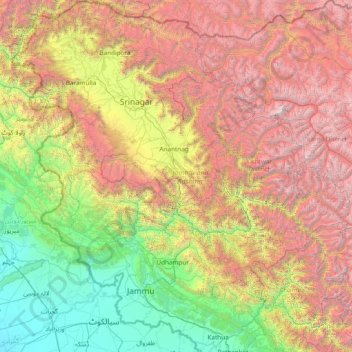
Nombre: Mapa topográfico Jammu and Kashmir, altitud, relieve.
Lugar: Jammu and Kashmir, India (32.27636 73.75003 34.78714 76.78032)
Altitud media: 2.430 m
Altitud mínima: 208 m
Altitud máxima: 7.015 m
Jammu and Kashmir is home to several valleys such as the Kashmir Valley, Tawi Valley, Chenab Valley, Poonch Valley, Sind Valley, and Lidder Valley. The Kashmir valley is 100 km (62 mi) wide and 15,520.3 km2 (5,992.4 sq mi) in area. The Himalayas divide the Kashmir valley from the Tibetan plateau while the Pir Panjal range, which encloses the valley from the west and the south, separates it from the Punjab Plain of the Indo-Gangetic Plain. Along the northeastern flank of the Valley runs the main range of the Himalayas. This valley has an average height of 1,850 metres (6,070 ft) above sea-level, but the surrounding Pir Panjal range has an average elevation of 10,000 feet (3,000 m). The Jhelum River is the major Himalayan river which flows through the Kashmir valley. The southern Jammu region is mostly mountainous, with the Shivaliks, the middle and the great Himalayas running parallel to each other in a southeast-northwest direction. A narrow southwestern strip constitutes fertile plains. The Chenab, Tawi and Ravi are important rivers flowing through the Jammu region.
Otros mapas topográficos
Haga clic en un mapa para ver su topografía, su altitud y su relieve.
Hyderabad
India > Telangana > Bahadurpura mandal
Hyderabad, Bahadurpura mandal, Hyderabad District, Telangana, India
Altitud media: 549 m
Bengaluru
India > Karnataka > Bangalore North
Bengaluru, Bangalore North, Bengaluru Urban District, Karnataka, India
Altitud media: 881 m
Bhopal
India > Madhya Pradesh > Huzur Tahsil
Bhopal, Huzur Tahsil, Bhopal District, Madhya Pradesh, 462001, India
Altitud media: 498 m
Anaikatti
India > Tamil Nadu > Coimbatore North
Anaikatti, Mannarkad, Palakkad District, Kerala, 678741, India
Altitud media: 623 m
Thiruvananthapuram
India > Kerala > Thiruvananthapuram
Thiruvananthapuram, Thiruvananthapuram District, Kerala, 695001, India
Altitud media: 33 m
Koloriang
India > Arunachal Pradesh > Koloriang HQ
Koloriang, Koloriang HQ, Kurung Kumey District, Arunachal Pradesh, India
Altitud media: 1.791 m
Kharki
India > Madhya Pradesh > Pandhana Tahsil
Kharki, Pandhana Tahsil, Khandwa District, Madhya Pradesh, India
Altitud media: 317 m
Sujanpur
India > Punjab > Pathankot Tahsil
Sujanpur, Pathankot Tahsil, Pathankot District, Punjab, 145023, India
Altitud media: 334 m
Kannamedi
India > Karnataka > Pavagada taluk
Kannamedi, Pavagada taluk, Tumakuru District, Karnataka, India
Altitud media: 708 m
Pedda Arikatla
India > Andhra Pradesh > Konakanamitla
Pedda Arikatla, Konakanamitla, Prakasam, Andhra Pradesh, 523245, India
Altitud media: 119 m
Ooty Lake
India > Tamil Nadu > Udhagamandalam > Udhagamandalam
Ooty Lake, Udhagamandalam, The Nilgiris District, Tamil Nadu, 643001, India
Altitud media: 2.235 m
Dharamshala
India > Himachal Pradesh > Dharamshala
Dharamshala, Kangra District, Himachal Pradesh, 176200, India
Altitud media: 1.781 m
Sion Fort
India > Maharashtra > Mumbai
Sion Fort, Road No 1, Sion Koliwada, F/N Ward, Zone 2, Mumbai, Maharashtra, 400022, India
Altitud media: 6 m
Hariharapura
India > Karnataka > Koppa taluk
Hariharapura, Koppa taluk, Chikkamagaluru District, Karnataka, 577120, India
Altitud media: 648 m
Pullalarevu
India > Andhra Pradesh > Raptadu
Pullalarevu, Raptadu, Anantapur, Andhra Pradesh, 515722, India
Altitud media: 389 m
Musti
India > Maharashtra > Solapur South
Musti, Solapur South, Solapur District, Maharashtra, 413573, India
Altitud media: 487 m
Mambakkam
India > Tamil Nadu > Tiruporur
Mambakkam, Tiruporur, Chengalpattu District, Tamil Nadu, 600127, India
Altitud media: 16 m
Tigawan
India > Madhya Pradesh > Panna Tahsil > Tilguwan
Tigawan, Tilguwan, Panna Tahsil, Panna District, Madhya Pradesh, India
Altitud media: 407 m
Devanahalli
India > Karnataka > Devanahalli taluk
Devanahalli, Devanahalli taluk, Bengaluru Rural District, Karnataka, 562110, India
Altitud media: 900 m
Gandhipuram
India > Tamil Nadu > Coonoor
Gandhipuram, Coonoor, Nilgiris District, Tamil Nadu, 643103, India
Altitud media: 1.686 m
Dahej
India > Gujarat > Vagra Taluka
Dahej, Vagra Taluka, Bharuch District, Gujarat, 393125, India
Altitud media: 6 m
Mangaluru
India > Karnataka > Mangaluru taluk
Mangaluru, Mangaluru taluk, Dakshina Kannada District, Karnataka, 575001, India
Altitud media: 25 m
Siliguri
India > West Bengal > Siliguri Subdivsion
Siliguri, Siliguri Subdivsion, Darjeeling District, West Bengal, India
Altitud media: 121 m
Navi Mumbai
India > Maharashtra > Thane > Navi Mumbai
Navi Mumbai, Mumbai Metropolitan Region, Thane, Maharashtra, 400706, India
Altitud media: 30 m