
Mapa topográfico Henley-on-Thames
Mapa interactivo
Haga clic en el mapa para ver la altitud.
Acerca de este mapa
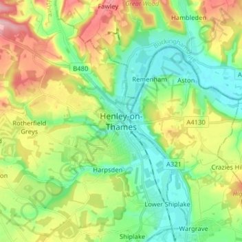
Nombre: Mapa topográfico Henley-on-Thames, altitud, relieve.
Altitud media: 78 m
Altitud mínima: 26 m
Altitud máxima: 169 m
Otros mapas topográficos
Haga clic en un mapa para ver su topografía, su altitud y su relieve.
Culham
United Kingdom > England > Oxfordshire > South Oxfordshire
Culham, South Oxfordshire, Oxfordshire, England, United Kingdom
Altitud media: 56 m
Ochre Pits
United Kingdom > England > Oxfordshire > South Oxfordshire > Horspath
Ochre Pits, Forest Hill with Shotover, Horspath, South Oxfordshire, Oxfordshire, South East England, England, United Kingdom
Altitud media: 114 m
Berrick Salome
United Kingdom > England > Oxfordshire > South Oxfordshire > Berrick Salome
Berrick Salome, South Oxfordshire, Oxfordshire, South East England, England, United Kingdom
Altitud media: 61 m