
Haz una donación
Mapa topográfico River Derwent
Haga clic en el mapa para ver la altitud.
Haz una donación
River Derwent
Rainfall and climate conditions vary slightly across the Derwent catchment area due to the topography. Annual rainfall ranges from averages of 600 millimetres (24 in) at Barmby Barrage to over 1,100 millimetres (43 in) at its source on the North York Moors.
Haz una donación
Acerca de este mapa
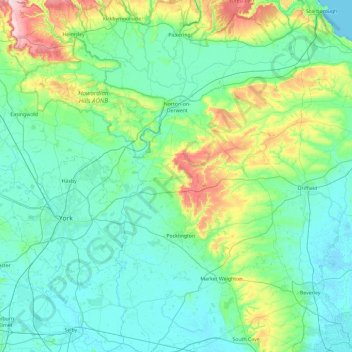
Nombre: Mapa topográfico River Derwent, altitud, relieve.
Altitud media: 66 m
Altitud mínima: -2 m
Altitud máxima: 404 m
Haz una donación
Otros mapas topográficos
Haga clic en un mapa para ver su topografía, su altitud y su relieve.
Haz una donación
Haz una donación
Haz una donación
Haz una donación
Haz una donación
Haz una donación
Haz una donación
Haz una donación
Haz una donación
Haz una donación
Haz una donación
Haz una donación
Bolton Castle
United Kingdom > England > North Yorkshire > Redmire > Castle Bolton
Altitud media: 250 m
Haz una donación
Thimbleby & Osmotherly Show field
United Kingdom > England > North Yorkshire > Thimbleby
Altitud media: 152 m
Haz una donación
Haz una donación
Haz una donación
Haz una donación
Haz una donación
Haz una donación
Haz una donación
Haz una donación
Haz una donación
Arkle Town
United Kingdom > England > North Yorkshire > Richmondshire > Arkle Town
Altitud media: 367 m
Haz una donación
Swinithwaite
United Kingdom > England > North Yorkshire > Richmondshire > West Witton > Swinithwaite
Altitud media: 205 m
Haz una donación
Haz una donación