
Mapa topográfico Door County
Mapa interactivo
Haga clic en el mapa para ver la altitud.
Acerca de este mapa
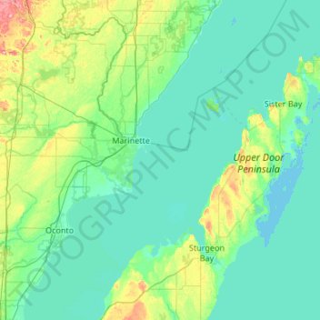
Nombre: Mapa topográfico Door County, altitud, relieve.
Lugar: Door County, Wisconsin, United States of America (44.67496 -87.73686 45.42985 -86.76396)
Altitud media: 191 m
Altitud mínima: 172 m
Altitud máxima: 315 m
The 102 ft high Brussels Hill (44°45′06″N 87°35′27″W / 44.75166°N 87.59093°W / 44.75166; -87.59093 (Brussels Hill), elevation 851 feet) is the highest point in the county. The nearby Red Hill Woods is the largest remaining maple–beech forest in the area.
Otros mapas topográficos
Haga clic en un mapa para ver su topografía, su altitud y su relieve.
Waukesha County
United States of America > Wisconsin
Waukesha County, Wisconsin, United States of America
Altitud media: 272 m
Gays Mills
United States of America > Wisconsin > Gays Mills
Gays Mills, Crawford County, Wisconsin, United States of America
Altitud media: 272 m