
Gracias por apoyar a este sitio ❤️
Haz una donación
Haz una donación
Mapa topográfico Welsberg
Haga clic en el mapa para ver la altitud.
Gracias por apoyar a este sitio ❤️
Haz una donación
Haz una donación
Acerca de este mapa
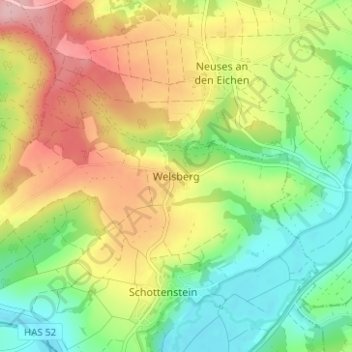
Nombre: Mapa topográfico Welsberg, altitud, relieve.
Altitud media: 329 m
Altitud mínima: 257 m
Altitud máxima: 421 m
Gracias por apoyar a este sitio ❤️
Haz una donación
Haz una donación
Otros mapas topográficos
Haga clic en un mapa para ver su topografía, su altitud y su relieve.
Meeder
Deutschland > Bayern > Landkreis Coburg
Auf der Sennigshöhe (geographische Koordinaten: 50° 21′ 20″ N, 10° 54′ 56″ O50.35555555555610.915555555556) betreibt die Deutsche Telekom AG seit 1965 eine Sendeanlage für UKW-Hörfunk, Mobilfunk und Richtfunk.
Altitud media: 398 m
Gracias por apoyar a este sitio ❤️
Haz una donación
Haz una donación
Gracias por apoyar a este sitio ❤️
Haz una donación
Haz una donación
96465
Deutschland > Bayern > Landkreis Coburg > Neustadt bei Coburg > Haarbrücken
Altitud media: 372 m
Gracias por apoyar a este sitio ❤️
Haz una donación
Haz una donación
Gracias por apoyar a este sitio ❤️
Haz una donación
Haz una donación
Gracias por apoyar a este sitio ❤️
Haz una donación
Haz una donación