
Mapa topográfico Mount Rochelle Nature Reserve
Mapa interactivo
Haga clic en el mapa para ver la altitud.
Acerca de este mapa
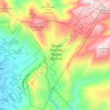
Nombre: Mapa topográfico Mount Rochelle Nature Reserve, altitud, relieve.
Altitud media: 844 m
Altitud mínima: 282 m
Altitud máxima: 1.585 m
Otros mapas topográficos
Haga clic en un mapa para ver su topografía, su altitud y su relieve.
Eerste River
RSA > Western Cape > Stellenbosch Local Municipality
Eerste River, Stellenbosch Local Municipality, Cape Winelands District Municipality, Western Cape, RSA
Altitud media: 372 m
Hottentots-Holland Nature Reserve
RSA > Western Cape > Stellenbosch Local Municipality
Hottentots-Holland Nature Reserve, Boegoekloof, Stellenbosch Ward 5, Stellenbosch Local Municipality, Overberg District Municipality, Western Cape, RSA
Altitud media: 557 m
Klapmutskop
RSA > Western Cape > Stellenbosch Local Municipality
Klapmutskop, Stellenbosch Local Municipality, Cape Winelands District Municipality, Western Cape, 7607, RSA
Altitud media: 261 m