
Gracias por apoyar a este sitio ❤️
Haz una donación
Haz una donación
Mapa topográfico Peace River
Haga clic en el mapa para ver la altitud.
Gracias por apoyar a este sitio ❤️
Haz una donación
Haz una donación
Peace River
Physiographically, the Town of Peace River lies within the Peace River Formation, a stratigraphical unit of middle Albian age in the Western Canadian Sedimentary Basin. The area developed on sediments of the former lake bottom of Glacial Lake Peace, which covered most of the areas in the region that were below 610 m in elevation.
Gracias por apoyar a este sitio ❤️
Haz una donación
Haz una donación
Acerca de este mapa
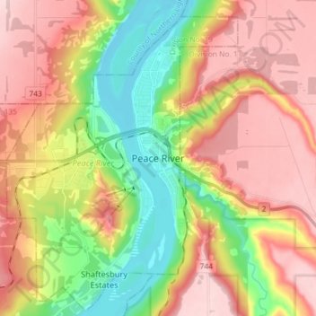
Nombre: Mapa topográfico Peace River, altitud, relieve.
Lugar: Peace River, Alberta, T8S 1P7, Canada (56.19371 -117.33108 56.27371 -117.25108)
Altitud media: 433 m
Altitud mínima: 308 m
Altitud máxima: 551 m
Gracias por apoyar a este sitio ❤️
Haz una donación
Haz una donación