
Gracias por apoyar a este sitio ❤️
Haz una donación
Haz una donación
Mapa topográfico Rockcliffe
Haga clic en el mapa para ver la altitud.
Gracias por apoyar a este sitio ❤️
Haz una donación
Haz una donación
Acerca de este mapa
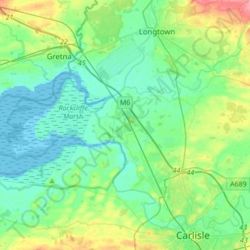
Nombre: Mapa topográfico Rockcliffe, altitud, relieve.
Lugar: Rockcliffe, Cumberland, England, United Kingdom (54.92772 -3.18281 54.98593 -2.93883)
Altitud media: 20 m
Altitud mínima: -2 m
Altitud máxima: 80 m
Gracias por apoyar a este sitio ❤️
Haz una donación
Haz una donación
Otros mapas topográficos
Haga clic en un mapa para ver su topografía, su altitud y su relieve.
Scafell Pike
United Kingdom > England > Cumberland
Scafell Pike (/ˈskɔːfɛl paɪk/) is a mountain in the Lake District region of Cumbria, England. It has an elevation of 978 metres (3,209 ft) above sea level, making it the highest and the most prominent mountain in England. The mountain is part of the Scafell massif, an extinct volcano, and is one of the…
Altitud media: 679 m
Gracias por apoyar a este sitio ❤️
Haz una donación
Haz una donación