
Mapa topográfico Dêqên County
Mapa interactivo
Haga clic en el mapa para ver la altitud.
Acerca de este mapa
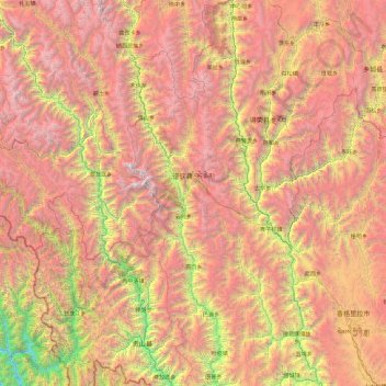
Nombre: Mapa topográfico Dêqên County, altitud, relieve.
Lugar: Dêqên County, Diqing, Yunnan, China (27.55823 98.59286 29.22572 99.52114)
Altitud media: 3.590 m
Altitud mínima: 1.022 m
Altitud máxima: 6.429 m
Being located at an altitude of 3,300 metres (10,800 ft), Dêqên lies in the transition between a subtropical highland climate (Köppen Cwb) and humid continental climate (Köppen Dwb), which is remarkable for its latitude. Although mean maximum temperatures, as in Lhasa and Shigatse, stay above freezing year-round, minima are below freezing from November to March, and temperatures average −1.4 °C (29.5 °F) in January, 13.6 °C (56.5 °F) in July, while the annual mean is 6.32 °C (43.4 °F). The town is nonetheless a little warmer during the winter than Shangri-La County to the east despite being slightly higher in elevation, due to its more southerly aspect. Rainfall is concentrated between June and September, accounting for nearly 60% of the annual total of 640 mm (25.2 in); snowfall is rare but still causes major transport problems in the winter. With monthly percent possible sunshine ranging from 29% in July to 62% in December, the county seat receives 1,989 hours of bright sunshine annually, with autumn and winter sunnier than spring and summer.
Otros mapas topográficos
Haga clic en un mapa para ver su topografía, su altitud y su relieve.
Nuozhadu Dam
China > Yunnan > Lancang Lahu Autonomous County
Nuozhadu Dam, Lancang Lahu Autonomous County, Pu'er City, Yunnan, China
Altitud media: 843 m
Dali Bai Autonomous Prefecture
Dali Bai Autonomous Prefecture, Yunnan, China
Altitud media: 2.168 m
Dulong
China > Yunnan > Maguan County
Dulong, Maguan County, Wenshan, Yunnan, China
Altitud media: 1.321 m
Jinghong City
Jinghong City, Xishuangbanna, Yunnan, 666100, China
Altitud media: 1.120 m
Manle
China > Yunnan > Mengla County
Manle, Mengla County, Xishuangbanna, Yunnan, 666100, China
Altitud media: 744 m
Wanbi
China > Yunnan > Dayao County > Wanbi
Wanbi, Dayao County, Chuxiong Yi Autonomous Prefecture, Yunnan, China
Altitud media: 1.485 m
Dabanqiao Subdistrict
Dabanqiao Subdistrict, Guandu District, Kunming, Yunnan, 650211, China
Altitud media: 2.093 m
Honghe Hani and Yi Autonomous Prefecture
Honghe Hani and Yi Autonomous Prefecture, Yunnan, 661300, China
Altitud media: 1.502 m
Diqing
China > Yunnan > Dêqên Tibetan Autonomous Prefecture > Jiantang
Diqing, Jiantang, Shangri-La County, Dêqên Tibetan Autonomous Prefecture, Yunnan, 674400, China
Altitud media: 3.328 m
Molong
China > Yunnan > Luoping County > Molong
Molong, Luoping County, Qujing City, Yunnan, China
Altitud media: 1.922 m
Dulong River
China > Yunnan > Dulongjiang
Dulong River, Dulongjiang, Gongshan Derung and Nu Autonomous County, Nujiang Lisu Autonomous Prefecture, Yunnan, China
Altitud media: 2.785 m