
Mapa topográfico Malone Lower
Mapa interactivo
Haga clic en el mapa para ver la altitud.
Acerca de este mapa
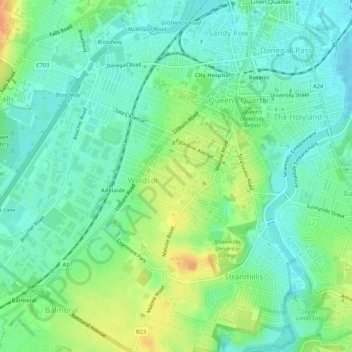
Nombre: Mapa topográfico Malone Lower, altitud, relieve.
Altitud media: 15 m
Altitud mínima: -2 m
Altitud máxima: 43 m
Otros mapas topográficos
Haga clic en un mapa para ver su topografía, su altitud y su relieve.
Forth River
United Kingdom > Northern Ireland > Belfast
Forth River, Belfast, County Antrim, Northern Ireland, BT13 3BU, United Kingdom
Altitud media: 73 m