
Mapa topográfico Peacehaven
Mapa interactivo
Haga clic en el mapa para ver la altitud.
Acerca de este mapa
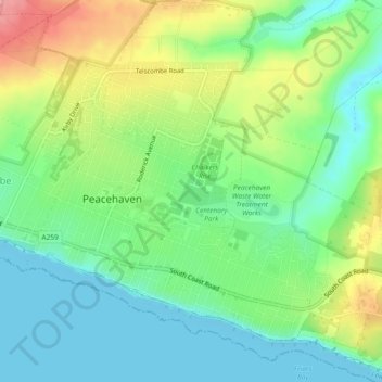
Nombre: Mapa topográfico Peacehaven, altitud, relieve.
Lugar: Peacehaven, Lewes, East Sussex, England, United Kingdom (50.78217 -0.01335 50.81152 0.03130)
Altitud media: 40 m
Altitud mínima: 0 m
Altitud máxima: 115 m
Otros mapas topográficos
Haga clic en un mapa para ver su topografía, su altitud y su relieve.
South Heighton
United Kingdom > England > East Sussex > Lewes
South Heighton, Lewes, East Sussex, England, BN9 0HL, United Kingdom
Altitud media: 37 m
Lewes
United Kingdom > England > East Sussex > Lewes
Lewes, East Sussex, England, United Kingdom
Altitud media: 40 m
Plumpton
United Kingdom > England > East Sussex > Lewes
Plumpton, Lewes, East Sussex, South East England, England, United Kingdom
Altitud media: 71 m