
Mapa topográfico Doring River
Mapa interactivo
Haga clic en el mapa para ver la altitud.
Acerca de este mapa
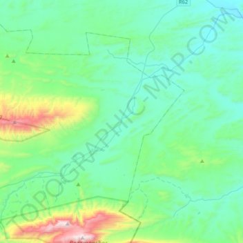
Nombre: Mapa topográfico Doring River, altitud, relieve.
Altitud media: 520 m
Altitud mínima: 277 m
Altitud máxima: 1.607 m
Otros mapas topográficos
Haga clic en un mapa para ver su topografía, su altitud y su relieve.
Warmwaterberg Nature Reserve
RSA > Western Cape > Swellendam Local Municipality
Warmwaterberg Nature Reserve, Tweefontein Road, Swellendam Ward 2, Swellendam Local Municipality, Overberg District Municipality, Western Cape, RSA
Altitud media: 713 m
Marloth Nature Reserve
RSA > Western Cape > Swellendam Local Municipality
Marloth Nature Reserve, Goedgeloof to Proteavallei, Langeberg Ward 7, Swellendam Local Municipality, Overberg District Municipality, Western Cape, RSA
Altitud media: 502 m
Vaalkop
RSA > Western Cape > Swellendam Local Municipality
Vaalkop, Swellendam Local Municipality, Overberg District Municipality, Western Cape, RSA
Altitud media: 994 m