
Gracias por apoyar a este sitio ❤️
Haz una donación
Haz una donación
Mapa topográfico Farndale
Haga clic en el mapa para ver la altitud.
Gracias por apoyar a este sitio ❤️
Haz una donación
Haz una donación
Farndale
With the population having decreased greatly from the 668 that is recorded in "A Topographical Dictionary of Yorkshire" by Thomas Lansdale published in 1822 when farndale East side had a population of 455 and Farndale West Side had a Population of 213.
Gracias por apoyar a este sitio ❤️
Haz una donación
Haz una donación
Acerca de este mapa
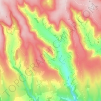
Nombre: Mapa topográfico Farndale, altitud, relieve.
Altitud media: 273 m
Altitud mínima: 86 m
Altitud máxima: 431 m
Gracias por apoyar a este sitio ❤️
Haz una donación
Haz una donación