
Haz una donación
Mapa topográfico Strumpshaw
Haga clic en el mapa para ver la altitud.
Haz una donación
Strumpshaw
The village lies a little distance from the river, on the slopes of Strumpshaw Hill, the highest area of land in the Norfolk Broads. Because of its elevation, Strumpshaw hosted, from the late 1790s through to the mid-1810s, a repeater station in the shutter telegraph chain linking the Admiralty in London with Great Yarmouth. The Wherry Lines railway line running between Norwich and Great Yarmouth and Lowestoft runs through the parish. Trains call at Buckenham railway station at weekends only.
Haz una donación
Acerca de este mapa
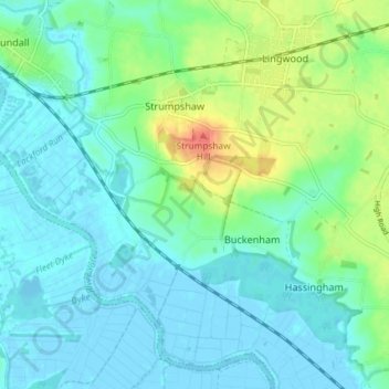
Nombre: Mapa topográfico Strumpshaw, altitud, relieve.
Altitud media: 11 m
Altitud mínima: -3 m
Altitud máxima: 46 m
Haz una donación
Otros mapas topográficos
Haga clic en un mapa para ver su topografía, su altitud y su relieve.
Great Witchingham Village Hall Park
United Kingdom > England > Norfolk > Broadland > Lenwade > Great Witchingham
Altitud media: 26 m
Haz una donación
Haz una donación
Haz una donación
Haz una donación
Haz una donación
Haz una donación
Haz una donación