
Haz una donación
Mapa topográfico Cumbernauld
Haga clic en el mapa para ver la altitud.
Haz una donación
Cumbernauld
Cumbernauld's name probably comes from the Gaelic comar nan allt, meaning "meeting of the burns or streams". There are differing views as to the etymology of this. One theory is that from its high point in the Central Belt, its streams flow both west to the River Clyde and east to the Firth of Forth so Cumbernauld's name is about it being on a watershed. Another theory ascribes the name to the meeting point of the Red Burn and Bog Stank streams within Cumbernauld Glen. 'Cumbernauld' is generally considered to be a Gaelic name. However, early forms containing Cumyr- hint at a Cumbric predecessor derived from *cömber, 'confluence' (c.f Welsh cymer, 'confluence'), synonymous with Aber. This seems to be suffixed with Cumbric *-ïn-alt, a topographical suffix perhaps referring to a hill or slope (Welsh yn allt, 'at a hill').
Haz una donación
Acerca de este mapa
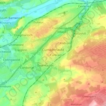
Nombre: Mapa topográfico Cumbernauld, altitud, relieve.
Lugar: Cumbernauld, North Lanarkshire, Scotland, United Kingdom (55.92079 -4.07169 55.96971 -3.93393)
Altitud media: 113 m
Altitud mínima: 42 m
Altitud máxima: 223 m
Haz una donación
Otros mapas topográficos
Haga clic en un mapa para ver su topografía, su altitud y su relieve.
Coatbridge
United Kingdom > Scotland > North Lanarkshire
The topography of Coatbridge was an important feature in the town's development during the industrial revolution. Coatbridge rests 60 metres below the "Slamannan plateau" and neighbouring Airdrie sits on its edge. The low-lying flat ground of Coatbridge was a vital factor in the siting of the town's blast…
Altitud media: 99 m
Airdrie
United Kingdom > Scotland > North Lanarkshire
Airdrie's name first appeared in the Register of the Great Seal of Scotland (Registrum Magni Sigilii Regum Scotorum) in 1373 as Ardre. By 1546 it had become Ardry and by 1587 it was known as Ardrie. In 1630 it finally appeared in the Register as Airdrie. Given the topography of the area, the most likely…
Altitud media: 135 m
Haz una donación
Cumbernauld
United Kingdom > Scotland > North Lanarkshire > Cumbernauld
Cumbernauld's name probably comes from the Gaelic comar nan allt, meaning "meeting of the burns or streams". There are differing views as to the etymology of this. One theory is that from its high point in the Central Belt, its streams flow both west to the River Clyde and east to the Firth of Forth so…
Altitud media: 111 m
Haz una donación
Haz una donación
Haz una donación
Haz una donación
Kilsyth
United Kingdom > Scotland > North Lanarkshire
Historically part of Stirlingshire, Kilsyth is at an elevation of 200 feet (60 metres) above sea level and occupies a narrow strip of land between the Kilsyth Hills to the north and the River Kelvin to the south. To the east and west it is bordered by marshland and bogs. The centre of the town is close to the…
Altitud media: 161 m
Haz una donación
Haz una donación
Woodhead Farm
United Kingdom > Scotland > North Lanarkshire > Birkenshaw > Woodhead Farm
Altitud media: 50 m
Haz una donación
Legbranock
United Kingdom > Scotland > North Lanarkshire > Newarthill > Legbranock
Altitud media: 139 m
Haz una donación
Barons Haugh Nature Reserve
United Kingdom > Scotland > North Lanarkshire > Motherwell
Altitud media: 52 m
Coatbridge
United Kingdom > Scotland > North Lanarkshire
The topography of Coatbridge was an important feature in the town's development during the Industrial Revolution. Coatbridge rests 60 metres below the "Slamannan plateau" and neighbouring Airdrie sits on its edge. The low-lying flat ground of Coatbridge was a vital factor in the siting of the town's blast…
Altitud media: 100 m
Airdrie
United Kingdom > Scotland > North Lanarkshire
Airdrie's name first appeared in the Register of the Great Seal of Scotland (Latin: Registrum Magni Sigilii Regum Scotorum) in 1373 as Ardre. By 1546 it had become Ardry and by 1587 it was known as Ardrie. In 1630 it finally appeared in the Register as Airdrie. Given the topography of the area, the most likely…
Altitud media: 135 m
Haz una donación
Kilsyth
United Kingdom > Scotland > North Lanarkshire
Historically part of Stirlingshire, Kilsyth is at an elevation of 200 feet (60 metres) above sea level and occupies a narrow strip of land between the Kilsyth Hills to the north and the River Kelvin to the south. To the east and west it is bordered by marshland and bogs. The centre of the town is close to the…
Altitud media: 161 m
Haz una donación
Haz una donación
Coatbridge
United Kingdom > Scotland > North Lanarkshire
The topography of Coatbridge was an important feature in the town's development during the Industrial Revolution. Coatbridge rests 60 metres below the "Slamannan plateau" and neighbouring Airdrie sits on its edge. The low-lying flat ground of Coatbridge was a vital factor in the siting of the town's blast…
Altitud media: 100 m
Airdrie
United Kingdom > Scotland > North Lanarkshire
Airdrie's name first appeared in the Register of the Great Seal of Scotland (Registrum Magni Sigilii Regum Scotorum) in 1373 as Ardre. By 1546 it had become Ardry and by 1587 it was known as Ardrie. In 1630 it finally appeared in the Register as Airdrie. Given the topography of the area, the most likely…
Altitud media: 135 m
Haz una donación