
Haz una donación
Mapa topográfico Finedon
Haga clic en el mapa para ver la altitud.
Haz una donación
Finedon
The town of Finedon rises to approximately 90 metres Above Ordinance Datum from the River Ise, with the historical centre of the settlement occupying a shallow south-west facing valley. The contemporary point of maximum elevation in the parish is the summit of the disused Sidegate Lane Landfill Site, located south of the town at approximately 108 metres Above Ordinance Datum. The parish covers a total area of 1,482 hectares (3,662 acres).
Haz una donación
Acerca de este mapa
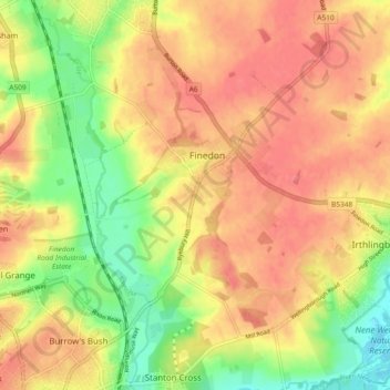
Nombre: Mapa topográfico Finedon, altitud, relieve.
Lugar: Finedon, North Northamptonshire, England, United Kingdom (52.31263 -0.68627 52.36156 -0.62272)
Altitud media: 75 m
Altitud mínima: 34 m
Altitud máxima: 100 m
Haz una donación
Otros mapas topográficos
Haga clic en un mapa para ver su topografía, su altitud y su relieve.
Irchester Country Park
United Kingdom > England > North Northamptonshire > Little Irchester
Altitud media: 60 m
River Nene Navigation
United Kingdom > England > North Northamptonshire > Irchester
Altitud media: 55 m
Haz una donación
Haz una donación
Haz una donación
Haz una donación
Haz una donación
Haz una donación
Haz una donación
Haz una donación