
Mapa topográfico Appin
Mapa interactivo
Haga clic en el mapa para ver la altitud.
Acerca de este mapa
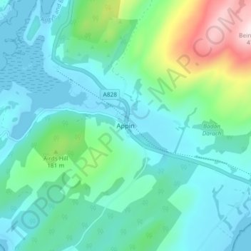
Nombre: Mapa topográfico Appin, altitud, relieve.
Lugar: Appin, Argyll and Bute, Scotland, PA38 4DB, United Kingdom (56.54179 -5.37849 56.58179 -5.33849)
Altitud media: 93 m
Altitud mínima: -1 m
Altitud máxima: 461 m
Otros mapas topográficos
Haga clic en un mapa para ver su topografía, su altitud y su relieve.
Fingal's Cave
United Kingdom > Scotland > Argyll and Bute
Fingal's Cave, Argyll and Bute, Scotland, United Kingdom
Altitud media: 0 m
Staffa
United Kingdom > Scotland > Argyll and Bute
Staffa, Argyll and Bute, Scotland, United Kingdom
Altitud media: 0 m
Garelochhead
United Kingdom > Scotland > Argyll and Bute
Garelochhead, Argyll and Bute, Scotland, G84 0AY, United Kingdom
Altitud media: 110 m
North Connel
United Kingdom > Scotland > Argyll and Bute
North Connel, Argyll and Bute, Scotland, PA37 1PL, United Kingdom
Altitud media: 19 m