
Mapa topográfico El Paso
Mapa interactivo
Haga clic en el mapa para ver la altitud.
Acerca de este mapa
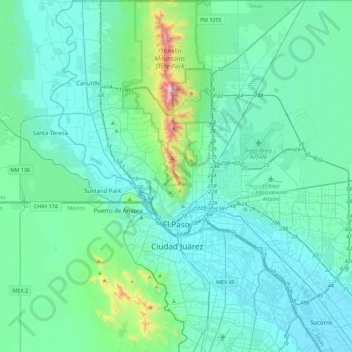
Nombre: Mapa topográfico El Paso, altitud, relieve.
Lugar: El Paso, El Paso County, Texas, United States (31.62222 -106.63578 32.00148 -106.19915)
Altitud media: 1.235 m
Altitud mínima: 1.110 m
Altitud máxima: 2.170 m
El Paso County was established in March 1850, with San Elizario as the first county seat. The United States Senate fixed a boundary between Texas and New Mexico at the 32nd parallel, thus largely ignoring history and topography. A military post called the "Post opposite El Paso" (meaning opposite El Paso del Norte, across the Rio Grande) was established in 1849 on Coons' Rancho beside the settlement of Franklin, which became the nucleus of the future El Paso, Texas; after the army left in 1851, the rancho went into default and was repossessed; in 1852, a post office was established on the rancho bearing the name El Paso as an example of cross-border town naming until El Paso del Norte was renamed Juarez in 1888. After changing hands twice more, the El Paso company was set up in 1859 and bought the property, hiring Anson Mills to survey and lay out the town, thus forming the current street plan of downtown El Paso.
Otros mapas topográficos
Haga clic en un mapa para ver su topografía, su altitud y su relieve.
Tigua
United States > Texas > El Paso County > El Paso
Tigua, El Paso, El Paso County, Texas, 79915, United States
Altitud media: 1.135 m
The Bite Food Park
United States > Texas > El Paso County > El Paso
The Bite Food Park, El Paso, El Paso County, Texas, United States
Altitud media: 1.196 m
Clint
United States > Texas > El Paso County
Clint, El Paso County, Texas, 79836, United States
Altitud media: 1.109 m
Mountain View
United States > Texas > El Paso County > El Paso
Mountain View, El Paso, El Paso County, Texas, 79906, United States
Altitud media: 1.190 m
Socorro
United States > Texas > El Paso County > Socorro > Socorro
Socorro, El Paso County, Texas, 79927, United States
Altitud media: 1.119 m