
Gracias por apoyar a este sitio ❤️
Haz una donación
Haz una donación
Mapa topográfico Monteagle
Haga clic en el mapa para ver la altitud.
Gracias por apoyar a este sitio ❤️
Haz una donación
Haz una donación
Monteagle
The town straddles a narrow stretch of the Cumberland Plateau known colloquially as "Monteagle Mountain". This stretch of the plateau is approximately 2 miles (3 km) wide, with steep drop-offs to the northwest and southeast. Monteagle lies at an elevation of just under 2,000 feet (610 m) above sea level. By comparison, two nearby cities, Cowan (to the northwest) and South Pittsburg (to the southeast), lie at elevations of less than 1,000 feet (300 m) above sea level.
Gracias por apoyar a este sitio ❤️
Haz una donación
Haz una donación
Acerca de este mapa
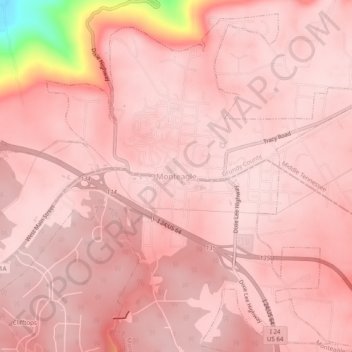
Nombre: Mapa topográfico Monteagle, altitud, relieve.
Altitud media: 566 m
Altitud mínima: 318 m
Altitud máxima: 595 m
Gracias por apoyar a este sitio ❤️
Haz una donación
Haz una donación