
Haz una donación
Mapa topográfico Brannenburg
Haga clic en el mapa para ver la altitud.
Haz una donación
Brannenburg
Blick von der Biber Richtung Wendelstein – rechts auf halber Höhe St. Margarethen
Haz una donación
Acerca de este mapa
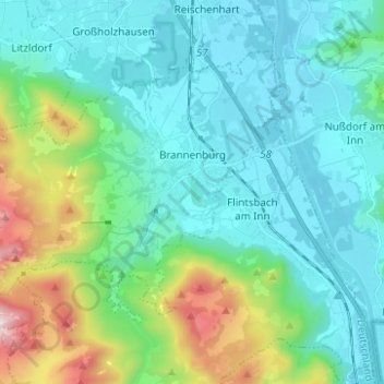
Nombre: Mapa topográfico Brannenburg, altitud, relieve.
Lugar: Brannenburg, Landkreis Rosenheim, Bayern, 83098, Deutschland (47.69854 12.00871 47.76007 12.13273)
Altitud media: 678 m
Altitud mínima: 447 m
Altitud máxima: 1.568 m
Haz una donación
Otros mapas topográficos
Haga clic en un mapa para ver su topografía, su altitud y su relieve.
Geigelstein
Deutschland > Bayern > Landkreis Rosenheim > Aschau im Chiemgau
1991 wurden große Flächen des Geigelstein als Naturschutzgebiet Geigelstein ausgewiesen. Das NSG Geigelstein hat eine Größe von 3135 Hektar und liegt zum Teil im Landkreis Rosenheim mit der Gemeinde Aschau sowie im Landkreis Traunstein mit der Gemeinde Schleching. Mit einem der größten Schutzgebiete auf…
Altitud media: 1.443 m
Kampenwand-Hauptgipfel
Deutschland > Bayern > Landkreis Rosenheim > Aschau im Chiemgau
Altitud media: 1.272 m
Haz una donación
Haz una donación
Haz una donación
Haz una donación
Haz una donación
Haz una donación
Haz una donación
Haz una donación
Bad Feilnbach
Deutschland > Bayern > Landkreis Rosenheim > Bad Feilnbach > Bad Feilnbach
Altitud media: 659 m
Hohenaschau
Deutschland > Bayern > Landkreis Rosenheim
Aschach | Aschau im Chiemgau | Attich | Aufham | Außerkoy | Außerwald | Bach | Berg | Brückl | Bucha | Einfang | Engerndorf | Fellerer | Göttersberg | Grattenbach | Grenzhub | Grünwald | Hainbach | Haindorf | Hammerbach | Hintergschwendt | Hohenaschau im Chiemgau | Höhenberg | Hub | Huben | Innerkoy |…
Altitud media: 863 m
Haz una donación
Haz una donación
Hochries
Deutschland > Bayern > Landkreis Rosenheim > Samerberg
Der Gipfel ist per Bahn von Grainbach aus zu erreichen. Vom Ort geht ein Sessellift zur Mittelstation auf 920 m Höhe. Von dort führt eine Kabinenbahn auf den Gipfel. Die Hochries ist als Rosenheimer „Hausberg“ beliebt bei Wanderern sowie insbesondere Gleitschirm- und Drachenfliegern.
Altitud media: 1.223 m
Haz una donación
Vagen
Deutschland > Bayern > Landkreis Rosenheim > Feldkirchen-Westerham
Vagen ist ein Ortsteil der Gemeinde Feldkirchen-Westerham im Landkreis Rosenheim. Das Pfarrdorf liegt auf einer Höhe von 525,7 m ü. NN. Vor der Gemeindegebietsreform 1972 war Vagen eine eigenständige Gemeinde.
Altitud media: 564 m
Haz una donación
Haz una donación
Haz una donación
Haz una donación
Haz una donación
Urschalling
Deutschland > Bayern > Landkreis Rosenheim > Prien am Chiemsee > Bach
Altitud media: 563 m
Haz una donación
Haz una donación
Kleinhöhenrain
Deutschland > Bayern > Landkreis Rosenheim > Feldkirchen-Westerham > Großhöhenrain
Altitud media: 561 m
Haz una donación
Haz una donación
Haz una donación
Happinger See
Deutschland > Bayern > Landkreis Rosenheim > Rosenheim > Pfraundorf
Altitud media: 451 m
Haz una donación
Haz una donación
Kleinholzhausen
Deutschland > Bayern > Landkreis Rosenheim > Raubling > Großholzhausen
Altitud media: 506 m
Walpersdorf
Deutschland > Bayern > Landkreis Rosenheim > Feldkirchen-Westerham > Unterlaus
Altitud media: 564 m
Heufeld
Deutschland > Bayern > Landkreis Rosenheim > Bruckmühl
Heufeld ist ein Gemeindeteil des Marktes Bruckmühl im Landkreis Rosenheim in Oberbayern. Der Gemeindeteil ist mit den Jahren komplett mit dem Gemeindeteil Bruckmühl zusammengewachsen und liegt auf einer Höhe von 492 m ü. NN.
Altitud media: 493 m
Haz una donación
Haz una donación