
Mapa topográfico Union Canal
Mapa interactivo
Haga clic en el mapa para ver la altitud.
Acerca de este mapa
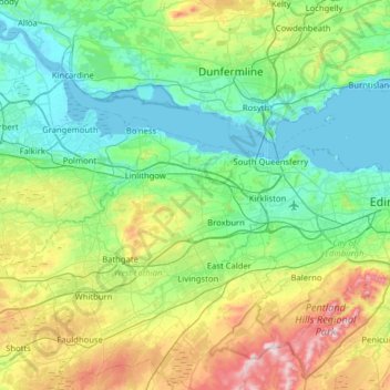
Nombre: Mapa topográfico Union Canal, altitud, relieve.
Lugar: Union Canal, West Lothian, Schotland, EH11 1AS, VK (55.91628 -3.84183 56.00172 -3.20835)
Altitud media: 136 m
Altitud mínima: -3 m
Altitud máxima: 564 m
Otros mapas topográficos
Haga clic en un mapa para ver su topografía, su altitud y su relieve.
Fort William
VK > Schotland > Fort William
Fort William, Highland, Schotland, PH33 6DH, VK
Altitud media: 122 m
Forth and Clyde Canal
Forth and Clyde Canal, East Dunbartonshire, Schotland, G81 1QA, VK
Altitud media: 130 m
Caledonian Canal
Caledonian Canal, Highland, Schotland, IV3 8RE, VK
Altitud media: 420 m
Linga
VK > Schotland > South Garth
Linga, South Garth, Shetland Islands, Schotland, VK
Altitud media: 7 m
Greenbraehead
VK > Schotland > Greenbraehead
Greenbraehead, Scottish Borders, Schotland, TD9 9SW, VK
Altitud media: 187 m