
Haz una donación
Mapa topográfico Eddleston
Haga clic en el mapa para ver la altitud.
Haz una donación
Acerca de este mapa
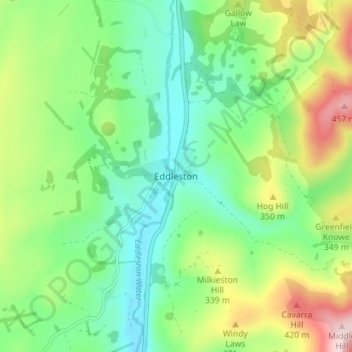
Nombre: Mapa topográfico Eddleston, altitud, relieve.
Altitud media: 282 m
Altitud mínima: 182 m
Altitud máxima: 481 m
Haz una donación
Otros mapas topográficos
Haga clic en un mapa para ver su topografía, su altitud y su relieve.
Haz una donación
Greenknowe Tower
United Kingdom > Scotland > Scottish Borders > Gordon > Nether Huntlywood
Altitud media: 157 m
Haz una donación
Haz una donación
Moffat Hills
United Kingdom > Scotland > Scottish Borders > Tweedsmuir
The Megget Stane (OS. Ref. NT152203) is by a cattle grid at the highest point between the Talla and Megget reservoirs on the minor road which runs from Tweedsmuir on the A701 to Cappercleuch by shore of St Mary's Loch. It is quite easy to miss the stone when coming from Talla as it is hidden by a gate. At an…
Altitud media: 430 m
Curling Pond
United Kingdom > Scotland > Scottish Borders > Earlston > Georgefield
Altitud media: 153 m
Hirsel Lake
United Kingdom > Scotland > Scottish Borders > Coldstream > The Hirsel
Altitud media: 37 m
Haz una donación