
Mapa topográfico Santiago de Compostela
Mapa interactivo
Haga clic en el mapa para ver la altitud.
Acerca de este mapa
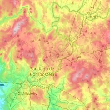
Nombre: Mapa topográfico Santiago de Compostela, altitud, relieve.
Lugar: Santiago de Compostela, Santiago, A Coruña, Galicia, Spain (42.82414 -8.63201 42.98963 -8.39009)
Altitud media: 277 m
Altitud mínima: 34 m
Altitud máxima: 527 m
According to medieval legend, the remains of the apostle James, son of Zebedee were brought to Galicia for burial, where they were lost. Eight hundred years later the light of a bright star guided a shepherd, Pelagius the Hermit, who was watching his flock at night to the burial site in Santiago de Compostela. This site was originally called Mount Libredon [gl] and its physical topography leads prevalent sea borne winds to clear the cloud deck immediately overhead. The shepherd quickly reported his discovery to the bishop of Iria, Theodemir. The bishop declared that the remains were those of the apostle James and immediately notified King Alfonso II in Oviedo. To honour St. James, the cathedral was built on the spot where his remains were said to have been found. The legend, which included numerous miraculous events, enabled the Catholic faithful to bolster support for their stronghold in northern Spain during the Christian crusades against the Moors, but also led to the growth and development of the city.