Mapa topográfico Lathom
Mapa interactivo
Haga clic en el mapa para ver la altitud.
Acerca de este mapa
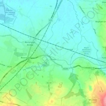
Nombre: Mapa topográfico Lathom, altitud, relieve.
Lugar: Lathom, West Lancashire, Lancashire, England, United Kingdom (53.56397 -2.85668 53.62824 -2.77591)
Altitud media: 26 m
Altitud mínima: 1 m
Altitud máxima: 108 m
Otros mapas topográficos
Haga clic en un mapa para ver su topografía, su altitud y su relieve.
Becconsall
United Kingdom > England > Lancashire > West Lancashire
Becconsall, West Lancashire, Lancashire, England, PR4 6SN, United Kingdom
Altitud media: 10 m
Ormskirk
United Kingdom > England > Lancashire > West Lancashire
Ormskirk, West Lancashire, Lancashire, England, L39 2XN, United Kingdom
Altitud media: 39 m
Skelmersdale
United Kingdom > England > Lancashire > West Lancashire
Skelmersdale, West Lancashire, Lancashire, England, United Kingdom
Altitud media: 76 m
Newburgh
United Kingdom > England > Lancashire > West Lancashire > Newburgh
Newburgh, West Lancashire, Lancashire, England, United Kingdom
Altitud media: 37 m
Skelmersdale
United Kingdom > England > Lancashire > West Lancashire
Skelmersdale, West Lancashire, Lancashire, England, WN8 6ES, United Kingdom
Altitud media: 68 m
Scarisbrick
United Kingdom > England > Lancashire > West Lancashire > Scarisbrick
Scarisbrick, West Lancashire, Lancashire, England, United Kingdom
Altitud media: 12 m
Holt Green
United Kingdom > England > Lancashire > West Lancashire > Aughton > Holt Green
Holt Green, Aughton, West Lancashire, Lancashire, England, L39 6SL, United Kingdom
Altitud media: 35 m
Burscough
United Kingdom > England > Lancashire > West Lancashire
Burscough, West Lancashire, Lancashire, England, United Kingdom
Altitud media: 14 m
Tarleton
United Kingdom > England > Lancashire > West Lancashire
Tarleton, West Lancashire, Lancashire, England, United Kingdom
Altitud media: 8 m
Dalton
United Kingdom > England > Lancashire > West Lancashire > Dalton
Dalton, West Lancashire, Lancashire, North West England, England, United Kingdom
Altitud media: 77 m
Bury Hey Wood
United Kingdom > England > Lancashire > West Lancashire > Appley Bridge > Robin Hood
Bury Hey Wood, Robin Hood, Wrightington, Appley Bridge, West Lancashire, Lancashire, England, United Kingdom
Altitud media: 106 m
Aughton
United Kingdom > England > Lancashire > West Lancashire > Town Green
Aughton, Town Green, West Lancashire, Lancashire, England, United Kingdom
Altitud media: 39 m
Up Holland
United Kingdom > England > Lancashire > West Lancashire > Upholland
Up Holland, Upholland, West Lancashire, Lancashire, England, United Kingdom
Altitud media: 89 m
North Meols
United Kingdom > England > Lancashire > West Lancashire > Banks
North Meols, Banks, West Lancashire, Lancashire, North West England, England, United Kingdom
Altitud media: 5 m
Parbold
United Kingdom > England > Lancashire > West Lancashire > Parbold
Parbold, West Lancashire, Lancashire, England, United Kingdom
Altitud media: 62 m
Bickerstaffe
United Kingdom > England > Lancashire > West Lancashire > Bickerstaffe
Bickerstaffe, West Lancashire, Lancashire, England, United Kingdom
Altitud media: 51 m
Tontine
United Kingdom > England > Lancashire > West Lancashire > Upholland > Tontine
Tontine, Up Holland, Upholland, West Lancashire, Lancashire, North West England, England, WN5 8UJ, United Kingdom
Altitud media: 101 m
Rufford
United Kingdom > England > Lancashire > West Lancashire
Rufford, West Lancashire, Lancashire, England, United Kingdom
Altitud media: 8 m
Wrightington
United Kingdom > England > Lancashire > West Lancashire
Wrightington, West Lancashire, Lancashire, England, United Kingdom
Altitud media: 80 m
Simonswood
United Kingdom > England > Lancashire > West Lancashire
Simonswood, West Lancashire, Lancashire, England, L33 4XX, United Kingdom
Altitud media: 36 m
Mere Brow
United Kingdom > England > Lancashire > West Lancashire
Mere Brow, West Lancashire, Lancashire, England, PR4 6JY, United Kingdom
Altitud media: 7 m