
Haz una donación
Mapa topográfico MacLean Settlement Brook
Haga clic en el mapa para ver la altitud.
Haz una donación
Acerca de este mapa
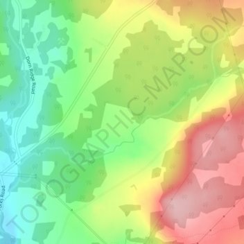
Nombre: Mapa topográfico MacLean Settlement Brook, altitud, relieve.
Altitud media: 103 m
Altitud mínima: 20 m
Altitud máxima: 200 m
Haz una donación
Otros mapas topográficos
Haga clic en un mapa para ver su topografía, su altitud y su relieve.
Manners Sutton Parish
Canada > New Brunswick > York County > Harvey Rural Community
Altitud media: 138 m
Haz una donación
Haz una donación
City of Fredericton
Canada > New Brunswick > York County
At an altitude of about 17 m (56 ft) above sea level, Fredericton is nestled in the Pennsylvanian Basin. It differs markedly from the geologically older parts of the province. There are prominently two distinct areas in the region that are divided around the area of Wilsey Road, in the east end of the city. In…
Altitud media: 73 m
Fredericton
Canada > New Brunswick > York County
At an altitude of about 17 m (56 ft) above sea level, Fredericton is nestled in the Pennsylvanian Basin. It differs markedly from the geologically older parts of the province. There are prominently two distinct areas in the region that are divided around the area of Wilsey Road, in the east end of the city. In…
Altitud media: 73 m
Haz una donación