
Gracias por apoyar a este sitio ❤️
Haz una donación
Haz una donación
Mapa topográfico Gorsey Leys
Haga clic en el mapa para ver la altitud.
Gracias por apoyar a este sitio ❤️
Haz una donación
Haz una donación
Acerca de este mapa
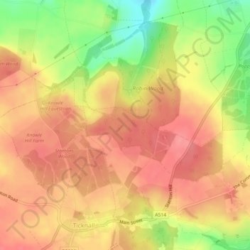
Nombre: Mapa topográfico Gorsey Leys, altitud, relieve.
Altitud media: 101 m
Altitud mínima: 50 m
Altitud máxima: 128 m
Gracias por apoyar a este sitio ❤️
Haz una donación
Haz una donación
Otros mapas topográficos
Haga clic en un mapa para ver su topografía, su altitud y su relieve.
Robin Wood
United Kingdom > England > Derbyshire > South Derbyshire > Stanton by Bridge CP
Altitud media: 92 m