
Gracias por apoyar a este sitio ❤️
Haz una donación
Haz una donación
Mapa topográfico Droeshout
Haga clic en el mapa para ver la altitud.
Gracias por apoyar a este sitio ❤️
Haz una donación
Haz una donación
Acerca de este mapa
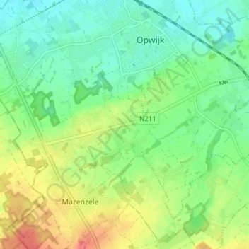
Nombre: Mapa topográfico Droeshout, altitud, relieve.
Altitud media: 33 m
Altitud mínima: 11 m
Altitud máxima: 70 m
Gracias por apoyar a este sitio ❤️
Haz una donación
Haz una donación
Otros mapas topográficos
Haga clic en un mapa para ver su topografía, su altitud y su relieve.
Mazenzele
België > Vlaams-Brabant > Halle-Vilvoorde > Opwijk
De bodem van Mazenzele bestaat uit zand en leem. Het landschap is heuvelachtig en de hoogte varieert van 35-68 meter.
Altitud media: 50 m