
Mapa topográfico Mount Banahaw
Mapa interactivo
Haga clic en el mapa para ver la altitud.
Acerca de este mapa
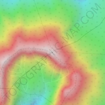
Nombre: Mapa topográfico Mount Banahaw, altitud, relieve.
Lugar: Mount Banahaw, Tayabas, Calabarzon, 4327, Philippines (14.06748 121.49227 14.06758 121.49237)
Altitud media: 1.730 m
Altitud mínima: 1.261 m
Altitud máxima: 2.145 m
The andesitic Banahaw volcanic complex is composed of several stratovolcanoes with Mount Banahaw, the largest with a maximum elevation of 2,170 metres (7,119 ft) above mean sea level. The summit is topped by a 1.5 by 3.5 kilometres (0.93 mi × 2.17 mi) and 210 metres (690 ft) deep crater that is breached on the southern rim believed to have been caused by the 1730 eruption. Prior to 1730, a lake occupied the summit crater of Mount Banahaw. The resulting flood destroyed the town of Sariaya, Quezon located below the mountain.[7]
Otros mapas topográficos
Haga clic en un mapa para ver su topografía, su altitud y su relieve.