
Gracias por apoyar a este sitio ❤️
Haz una donación
Haz una donación
Mapa topográfico Little Heath
Haga clic en el mapa para ver la altitud.
Gracias por apoyar a este sitio ❤️
Haz una donación
Haz una donación
Acerca de este mapa
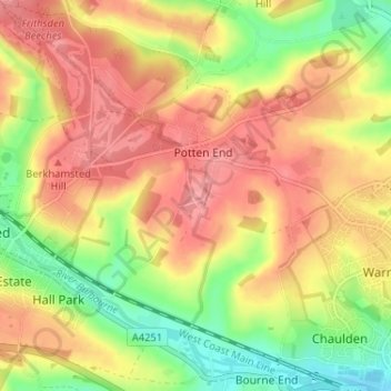
Nombre: Mapa topográfico Little Heath, altitud, relieve.
Altitud media: 138 m
Altitud mínima: 86 m
Altitud máxima: 178 m
Gracias por apoyar a este sitio ❤️
Haz una donación
Haz una donación
Otros mapas topográficos
Haga clic en un mapa para ver su topografía, su altitud y su relieve.
Frithsden Beeches
United Kingdom > England > Hertfordshire > Dacorum > Potten End
Altitud media: 160 m