
Mapa topográfico Great Langdale
Mapa interactivo
Haga clic en el mapa para ver la altitud.
Acerca de este mapa
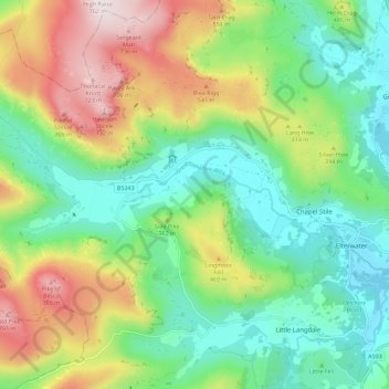
Nombre: Mapa topográfico Great Langdale, altitud, relieve.
Altitud media: 299 m
Altitud mínima: 52 m
Altitud máxima: 759 m
Pike of Stickle, also known as Pike o’ Stickle, reaches a height of 709 metres (2,326 ft). The rearward slopes show evidence of the Pavey Ark Member, pebbly sandstone and breccia. The Langdale face displays several strata: from the top the Lingmell Formation, Crinkle Member and Bad Step Tuff. These are composed, respectively, of tuff, lapilli-tuff and breccia; rhyolitic tuff and breccia; and rhyolitic lava-like tuff.[2] The altitude places Loft Crag and Gimmer Crag within sightlines to east-southeast while Bowfell is 3 kilometres (1.9 mi) west-southwest. The Southern Fells and Skiddaw are also potentially visible.[3]