
Mapa topográfico Dyrham
Haga clic en el mapa para ver la altitud.
Acerca de este mapa
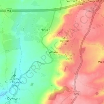
Nombre: Mapa topográfico Dyrham, altitud, relieve.
Altitud media: 139 m
Altitud mínima: 68 m
Altitud máxima: 218 m
Otros mapas topográficos
Haga clic en un mapa para ver su topografía, su altitud y su relieve.
Oldbury-upon-Severn
United Kingdom > England > South Gloucestershire > Oldbury on Severn
Altitud media: 11 m
Pucklechurch
United Kingdom > England > South Gloucestershire
The land of Pucklechurch is relatively prominent in elevation compared to surrounding areas and as such it was selected in the Bronze Age as the site of a tumulus (round barrow) at Shortwood Hill.
Altitud media: 98 m
Pucklechurch
United Kingdom > England > South Gloucestershire
Shortwood is located to the east of the A4174 and to the west of Pucklechurch village, sitting lower in the landscape topography against the Pucklechurch ridge and adjacent to Emerson’s Green and Mangotsfield. It is largely a linear settlement (comprising approximately 73 households) washed over by the Green…
Altitud media: 98 m