
Mapa topográfico Ahaura River
Mapa interactivo
Haga clic en el mapa para ver la altitud.
Acerca de este mapa
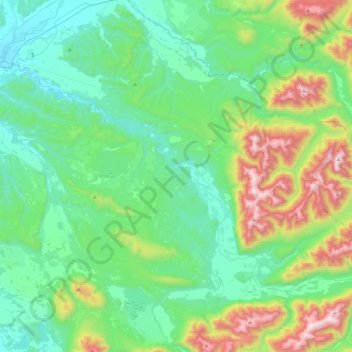
Nombre: Mapa topográfico Ahaura River, altitud, relieve.
Lugar: Ahaura River, Grey District, West Coast, 7843, New Zealand (-42.56351 171.52317 -42.34742 171.97023)
Altitud media: 386 m
Altitud mínima: 47 m
Altitud máxima: 1.459 m
Otros mapas topográficos
Haga clic en un mapa para ver su topografía, su altitud y su relieve.
Greymouth
New Zealand > West Coast > Grey District
Greymouth, Grey District, West Coast, 7801, New Zealand
Altitud media: 40 m
Atarau
New Zealand > West Coast > Grey District
Atarau, Grey District, West Coast, 7843, New Zealand
Altitud media: 59 m
Taylorville
New Zealand > West Coast > Grey District
Taylorville, Grey District, West Coast, New Zealand
Altitud media: 125 m
Lake Brunner
New Zealand > West Coast > Grey District > Moana
Lake Brunner, Moana, Grey District, West Coast, New Zealand
Altitud media: 168 m
Ngahere
New Zealand > West Coast > Grey District > Ngahere
Ngahere, Grey District, West Coast, 7804, New Zealand
Altitud media: 49 m