
Mapa topográfico Snowdon
Mapa interactivo
Haga clic en el mapa para ver la altitud.
Acerca de este mapa
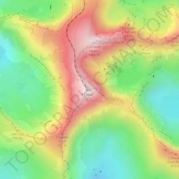
Nombre: Mapa topográfico Snowdon, altitud, relieve.
Lugar: Snowdon, Gwynedd, Wales, LL55 4UL, United Kingdom (53.06844 -4.07628 53.06854 -4.07618)
Altitud media: 692 m
Altitud mínima: 390 m
Altitud máxima: 1.061 m
Snowdon (/ˈsnoʊdən/) or Yr Wyddfa (pronounced [ər ˈʊɨ̞̯ðva] (listen)) is the highest mountain in Wales, at an elevation of 1,085 metres (3,560 ft) above sea level, and the highest point in the British Isles outside the Scottish Highlands. It is located in Snowdonia National Park (Parc Cenedlaethol Eryri) in Gwynedd (historic county of Caernarfonshire).
Otros mapas topográficos
Haga clic en un mapa para ver su topografía, su altitud y su relieve.
Sand Dunes
United Kingdom > Wales > Gwynedd > Barmouth
Sand Dunes, Arthog, Barmouth, Gwynedd, Wales, United Kingdom
Altitud media: 10 m
Porth Dinllaen
United Kingdom > Wales > Gwynedd > Morfa Nefyn
Porth Dinllaen, Nefyn, Morfa Nefyn, Gwynedd, Wales, LL53 6DB, United Kingdom
Altitud media: 8 m