
Haz una donación
Mapa topográfico Reading
Haga clic en el mapa para ver la altitud.
Haz una donación
Reading
Mary Russell Mitford lived in Reading for a number of years and then spent the rest of her life just outside the town at Three Mile Cross and Swallowfield. The fictional Belford Regis of her eponymous novel, first published in 1835, is largely based on Reading. Described with topographical accuracy, it is still possible to follow the steps of the novel's characters in present-day Reading.
Haz una donación
Acerca de este mapa
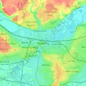
Nombre: Mapa topográfico Reading, altitud, relieve.
Lugar: Reading, England, RG1 1JL, United Kingdom (51.41642 -1.01007 51.49642 -0.93007)
Altitud media: 56 m
Altitud mínima: 32 m
Altitud máxima: 108 m
Haz una donación
Otros mapas topográficos
Haga clic en un mapa para ver su topografía, su altitud y su relieve.
Berkshire
United Kingdom > England > Reading
All of the county is drained by the Thames. Berkshire divides into two topological (and associated geological) sections: east and west of Reading. North-east Berkshire has the low calciferous (limestone) m-shaped bends of the Thames south of which is a broader, clayey, gravelly former watery plain or belt from…
Altitud media: 100 m
Haz una donación