
Mapa topográfico Guilin
Mapa interactivo
Haga clic en el mapa para ver la altitud.
Acerca de este mapa
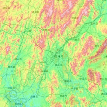
Nombre: Mapa topográfico Guilin, altitud, relieve.
Lugar: Guilin, Guangxi, China (24.26275 109.61164 26.38787 111.48759)
Altitud media: 477 m
Altitud mínima: 65 m
Altitud máxima: 2.046 m
Guilin (Standard Zhuang: Gveilinz; alternatively romanized as Kweilin) is a prefecture-level city in the northeast of China's Guangxi Zhuang Autonomous Region. It is situated on the west bank of the Li River and borders Hunan to the north. Its name means "forest of sweet osmanthus", owing to the large number of fragrant sweet osmanthus trees located in the region. The city has long been renowned for its scenery of karst topography.
Otros mapas topográficos
Haga clic en un mapa para ver su topografía, su altitud y su relieve.
Zhongshan
China > Guangxi > Zhongshan County
Zhongshan, Zhongshan County, Hezhou, Guangxi, China
Altitud media: 246 m
Lingchuan County
Lingchuan County, Guilin, Guangxi, 541203, China
Altitud media: 431 m
Guanyang County
Guanyang County, Guilin, Guangxi, 541607, China
Altitud media: 635 m
Luocheng Mulao Autonomous County
Luocheng Mulao Autonomous County, Yule, Hechi, Guangxi, China
Altitud media: 226 m
Pingnan County
Pingnan County, Chini, Guigang, Guangxi, China
Altitud media: 36 m