
Mapa topográfico Garthorpe
Mapa interactivo
Haga clic en el mapa para ver la altitud.
Acerca de este mapa
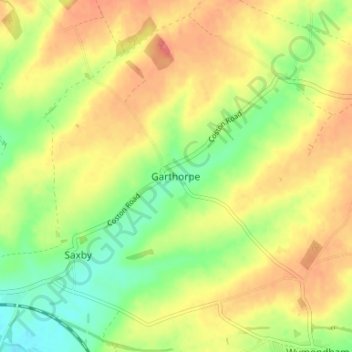
Nombre: Mapa topográfico Garthorpe, altitud, relieve.
Altitud media: 115 m
Altitud mínima: 81 m
Altitud máxima: 145 m
Otros mapas topográficos
Haga clic en un mapa para ver su topografía, su altitud y su relieve.
Sproxton
United Kingdom > England > Leicestershire > Borough of Melton > Sproxton
Sproxton, Borough of Melton, Leicestershire, England, United Kingdom
Altitud media: 137 m
Eye Kettleby
United Kingdom > England > Leicestershire > Borough of Melton > Melton Mowbray
Eye Kettleby, Melton Mowbray, Borough of Melton, Leicestershire, England, LE14 2TD, United Kingdom
Altitud media: 95 m
Somerby
United Kingdom > England > Leicestershire > Borough of Melton
Somerby, Borough of Melton, Leicestershire, England, LE14 2QA, United Kingdom
Altitud media: 169 m
Long Clawson
United Kingdom > England > Leicestershire > Borough of Melton
Long Clawson, Borough of Melton, Leicestershire, England, LE14 4NA, United Kingdom
Altitud media: 78 m
Frisby on the Wreake
United Kingdom > England > Leicestershire > Borough of Melton
Frisby on the Wreake, Borough of Melton, Leicestershire, England, LE14 2NQ, United Kingdom
Altitud media: 83 m
Buckminster
United Kingdom > England > Leicestershire > Borough of Melton
Buckminster, Borough of Melton, Leicestershire, England, NG33 5SB, United Kingdom
Altitud media: 138 m