
Haz una donación
Mapa topográfico Emi Koussi
Haga clic en el mapa para ver la altitud.
Haz una donación
Emi Koussi
Emi Koussi (also known as Emi Koussou) is a high pyroclastic shield volcano that lies at the southeast end of the Tibesti Mountains in the central Sahara, in the northern Borkou Region of northern Chad. The highest mountain of the Sahara, the volcano is one of several in the Tibesti range, and reaches an elevation of 3,415 metres (11,204 ft), rising 3 km (1.9 mi) above the surrounding sandstone plains. The volcano is 60–70 kilometres (37–43 mi) wide and has a volume of 2,500 cubic kilometres (600 cu mi).
Haz una donación
Acerca de este mapa
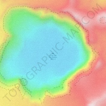
Nombre: Mapa topográfico Emi Koussi, altitud, relieve.
Lugar: Emi Koussi, Tibesti, Chad (19.83259 18.56085 19.83269 18.56095)
Altitud media: 2.904 m
Altitud mínima: 2.666 m
Altitud máxima: 3.203 m
Haz una donación
Otros mapas topográficos
Haga clic en un mapa para ver su topografía, su altitud y su relieve.