
Mapa topográfico Netherthong
Mapa interactivo
Haga clic en el mapa para ver la altitud.
Acerca de este mapa
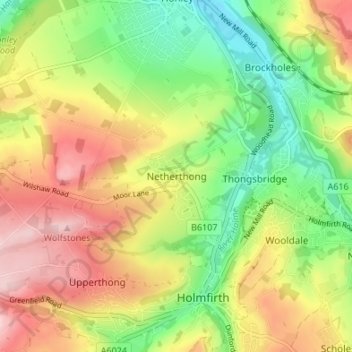
Nombre: Mapa topográfico Netherthong, altitud, relieve.
Altitud media: 204 m
Altitud mínima: 101 m
Altitud máxima: 322 m
Otros mapas topográficos
Haga clic en un mapa para ver su topografía, su altitud y su relieve.
Millbridge
United Kingdom > England > Kirklees
Millbridge, Kirklees, West Yorkshire, England, WF15 7ER, United Kingdom
Altitud media: 103 m
Kirkburton
United Kingdom > England > Kirklees
Kirkburton, Highburton, Kirklees, West Yorkshire, England, United Kingdom
Altitud media: 148 m
Denby Dale
United Kingdom > England > Kirklees > Scissett
Denby Dale, Scissett, Kirklees, West Yorkshire, England, United Kingdom
Altitud media: 168 m
Gomersal
United Kingdom > England > Kirklees > Gomersal
Gomersal, Kirklees, West Yorkshire, Yorkshire and the Humber, England, BD19 4JR, United Kingdom
Altitud media: 133 m
Kirklees
United Kingdom > England > Kirklees
Kirklees, Yorkshire and the Humber, England, United Kingdom
Altitud media: 220 m