
Mapa topográfico North District
Mapa interactivo
Haga clic en el mapa para ver la altitud.
Acerca de este mapa
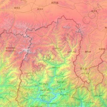
Nombre: Mapa topográfico North District, altitud, relieve.
Lugar: North District, North Sikkim District, Sikkim, Inde (27.02667 87.86000 28.30667 89.14000)
Altitud media: 3.842 m
Altitud mínima: 269 m
Altitud máxima: 8.489 m
Otros mapas topográficos
Haga clic en un mapa para ver su topografía, su altitud y su relieve.
Rangpo
Inde > Sikkim > Pakyong subdivision
Rangpo, Pakyong subdivision, Pakyong District, Sikkim, 737132, Inde
Altitud media: 731 m
Lachung
Inde > Sikkim > Chungthang
Lachung, Chungthang, Mangan District, Sikkim, Inde
Altitud media: 3.617 m
East Sikkim District
Inde > Sikkim > Pakyong subdivision
East Sikkim District, Pakyong subdivision, Pakyong district, Sikkim, Inde
Altitud media: 2.107 m
South District
South District, Namchi District, Sikkim, 737139, Inde
Altitud media: 2.687 m