
Haz una donación
Mapa topográfico Grantham
Haga clic en el mapa para ver la altitud.
Haz una donación
Acerca de este mapa
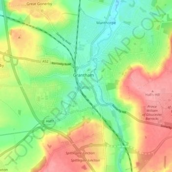
Nombre: Mapa topográfico Grantham, altitud, relieve.
Altitud media: 84 m
Altitud mínima: 43 m
Altitud máxima: 135 m
Haz una donación
Otros mapas topográficos
Haga clic en un mapa para ver su topografía, su altitud y su relieve.
Haz una donación
Haz una donación
Moor Barn
United Kingdom > England > Lincolnshire > South Kesteven > Hough-on-the-Hill
Altitud media: 31 m
Haz una donación
Old Somerby
United Kingdom > England > Lincolnshire > South Kesteven > Old Somerby
Altitud media: 115 m
Haz una donación
Haz una donación
Haz una donación
Haz una donación
Sempringham
United Kingdom > England > Lincolnshire > South Kesteven > Pointon
Sempringham consists of a church and a holy well, with other houses east from the church scattered along the B1177 between Pointon and Billingborough. The church stands at an altitude of about 52 feet (16 m), on land rising out of flat fenland. Pointon is the chief township of the civil parish, which includes…
Altitud media: 16 m
Haz una donación
Haz una donación
Haz una donación
Haz una donación
Haz una donación
Uffington Park
United Kingdom > England > Lincolnshire > South Kesteven > Uffington
Altitud media: 30 m
Haz una donación
Haz una donación
Little Haw Wood
United Kingdom > England > Lincolnshire > South Kesteven > Castle Bytham
Altitud media: 92 m
Haz una donación
Witham on the Hill
United Kingdom > England > Lincolnshire > South Kesteven > Witham on the Hill
Altitud media: 43 m
Haz una donación
Haz una donación
Haz una donación
Grimsthorpe
United Kingdom > England > Lincolnshire > South Kesteven > Grimsthorpe
Altitud media: 55 m
Haz una donación
Haz una donación
Haz una donación
Haz una donación