
Gracias por apoyar a este sitio ❤️
Haz una donación
Haz una donación
Mapa topográfico Butte
Haga clic en el mapa para ver la altitud.
Gracias por apoyar a este sitio ❤️
Haz una donación
Haz una donación
Butte
Butte's South district, situated at a lower elevation below the hillside that comprises northern Butte, has historically been home to working-class neighborhoods. Gold mines originally populated south Butte before it was platted for the Union Pacific Railroad in 1881.
Gracias por apoyar a este sitio ❤️
Haz una donación
Haz una donación
Acerca de este mapa
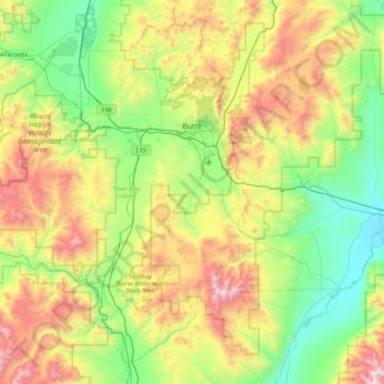
Nombre: Mapa topográfico Butte, altitud, relieve.
Lugar: Butte, Silver Bow County, Montana, United States (45.62485 -113.08554 46.18547 -112.19004)
Altitud media: 1.909 m
Altitud mínima: 1.322 m
Altitud máxima: 3.175 m
Gracias por apoyar a este sitio ❤️
Haz una donación
Haz una donación
Otros mapas topográficos
Haga clic en un mapa para ver su topografía, su altitud y su relieve.