
Gracias por apoyar a este sitio ❤️
Haz una donación
Haz una donación
Mapa topográfico The Narth
Haga clic en el mapa para ver la altitud.
Gracias por apoyar a este sitio ❤️
Haz una donación
Haz una donación
Acerca de este mapa
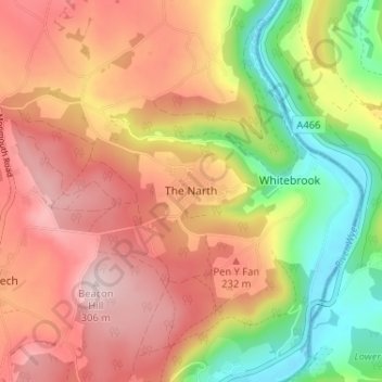
Nombre: Mapa topográfico The Narth, altitud, relieve.
Lugar: The Narth, Monmouthshire, Wales, NP25 4QW, United Kingdom (51.73452 -2.71173 51.77452 -2.67173)
Altitud media: 170 m
Altitud mínima: 5 m
Altitud máxima: 303 m
Gracias por apoyar a este sitio ❤️
Haz una donación
Haz una donación
Otros mapas topográficos
Haga clic en un mapa para ver su topografía, su altitud y su relieve.
Gracias por apoyar a este sitio ❤️
Haz una donación
Haz una donación
Gracias por apoyar a este sitio ❤️
Haz una donación
Haz una donación