
Mapa topográfico Charleston
Mapa interactivo
Haga clic en el mapa para ver la altitud.
Acerca de este mapa
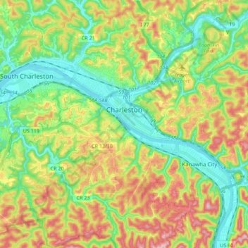
Nombre: Mapa topográfico Charleston, altitud, relieve.
Lugar: Charleston, Kanawha County, West Virginia, United States (38.28114 -81.72778 38.40427 -81.55946)
Altitud media: 264 m
Altitud mínima: 172 m
Altitud máxima: 409 m
Charleston has a four-season humid subtropical climate (Köppen Cfa) with continental climate (Dfa) elements. Especially in winter, Charleston's average temperatures are warmer than the rest of the state, due to the city being west of the higher elevations. Spring is the most unpredictable season, and spring-like weather usually arrives in late March or early April. From the beginning of March through early May, temperatures can vary considerably and it is not unusual at this time for day-to-day temperature fluctuations to exceed 20 °F (11 °C). Temperatures warm up considerably in late May, with warm summer-like days. Summer is warm to hot, with 23 days of highs at or above 90 °F (32 °C), sometimes reaching 95 °F (35 °C), often accompanied by high humidity. Autumn features crisp evenings that warm quickly to mild to warm afternoons. Winters are chilly, with a January daily average of 34.4 °F (1.3 °C), and with a mean of 16 days with maxima at or below the freezing mark. Snowfall generally occurs from late November to early April, with the heaviest period being January and February. However, major snowstorms of more than 10 inches (25 cm) are rare. The area averages about 3.5 inches (89 mm) of precipitation each month. Thunderstorms are frequent during the late spring and throughout the summer, and occasionally they can be quite severe, producing the rare tornado.
Otros mapas topográficos
Haga clic en un mapa para ver su topografía, su altitud y su relieve.
Pinch
United States > West Virginia > Kanawha County > Pinch
Pinch, Kanawha County, West Virginia, 25156, United States
Altitud media: 255 m
Decota
United States > West Virginia > Kanawha County
Decota, Kanawha County, West Virginia, United States
Altitud media: 547 m
Tornado
United States > West Virginia > Kanawha County
Tornado, Kanawha County, West Virginia, 25202, United States
Altitud media: 224 m
Blue Creek
United States > West Virginia > Kanawha County
Blue Creek, Kanawha County, West Virginia, 02507, United States
Altitud media: 249 m
East Side
United States > West Virginia > Kanawha County > Charleston
East Side, Charleston, Kanawha County, West Virginia, 25389, United States
Altitud media: 222 m
Blakeley
United States > West Virginia > Kanawha County
Blakeley, Kanawha County, West Virginia, 25160, United States
Altitud media: 408 m
Loudon Heights
United States > West Virginia > Kanawha County > Charleston
Loudon Heights, Charleston, Kanawha County, West Virginia, 25301, United States
Altitud media: 264 m
Forest Hills
United States > West Virginia > Kanawha County > Charleston
Forest Hills, Charleston, Kanawha County, West Virginia, 25314, United States
Altitud media: 240 m
Hollygrove
United States > West Virginia > Kanawha County
Hollygrove, Kanawha County, West Virginia, 25103, United States
Altitud media: 327 m
Bream
United States > West Virginia > Kanawha County
Bream, Kanawha County, West Virginia, United States
Altitud media: 253 m
Clendenin
United States > West Virginia > Kanawha County
Clendenin, Kanawha County, West Virginia, United States
Altitud media: 262 m
United
United States > West Virginia > Kanawha County
United, Kanawha County, West Virginia, 25060, United States
Altitud media: 607 m