
Gracias por apoyar a este sitio ❤️
Haz una donación
Haz una donación
Mapa topográfico Blue Mountain Park
Haga clic en el mapa para ver la altitud.
Gracias por apoyar a este sitio ❤️
Haz una donación
Haz una donación
Acerca de este mapa
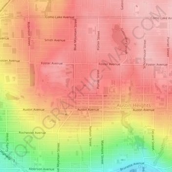
Nombre: Mapa topográfico Blue Mountain Park, altitud, relieve.
Altitud media: 119 m
Altitud mínima: 9 m
Altitud máxima: 169 m
Gracias por apoyar a este sitio ❤️
Haz una donación
Haz una donación
Otros mapas topográficos
Haga clic en un mapa para ver su topografía, su altitud y su relieve.
Crystal Falls
Canada > British Columbia > Metro Vancouver Regional District > Coquitlam
Altitud media: 221 m
Coquitlam
Canada > British Columbia > Metro Vancouver Regional District > Coquitlam
Southwest Coquitlam comprises the original core of the city, with Maillardville and Fraser River industrial sector giving way to the large residential areas of Austin Heights, colloquially referred to as "The Bump" due to its high and flat plateau topography. These older residences, with larger property…
Altitud media: 230 m